Thursday, August 25, 2011

Mount Temple

I finally got some time off from school, so recently Sam Johnson and I met up in Missoula for a quick trip to the Canadian Rockies. We managed to do one route, the Greenwood/Jones on the north face of Mt. Tempe (V 5.8 A1 ca. 4000'), easily visible from the Lake Louise townsite. I borrowed the photo below from the internet, Parks Canada website I think. It shows our route very well: the sun/shade ridge just left of the pine tree superimposed on the face. We considered the Greenwood/Locke, but 'The Dolphin' was rather melted out (more than in this photo) and subject to copious rockfall in the non-freezing temps. We decided the G/J was the only safe route on the face.
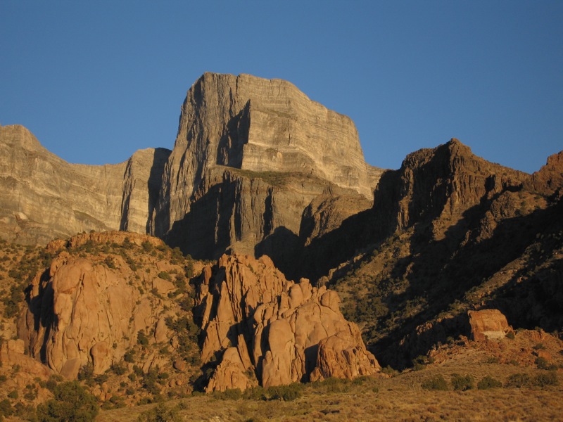
Below is Sam approaching the base of the face, with hundreds of acres of petrified ocean bottom looming above.

Lots of third classing...


Finally roped up, I think we did about 17 belayed pitches.


Still climbing on the bottom of an ancient ocean, Sam traversed to avoid a jellyfish...

Fortunately the rock quality improved as we got higher, the limestone gave way to beautiful quartzite...

We were glad to be on a ridge, safe from rockfall...


You can see the village of Lake Louise carved out of the trees behind Sam

Sam lead the crux pitch just as a thunderstorm was rolling through the valley. Luckily he got through it before the rock was too wet, but not before it got dark. I followed as fast as possible, and we immediately hunkered down on a small ledge until the rain passed. Amazingly, we never got the soaking we expected, despite being surrounded by dark clouds and verga. By that time we were dozing off, so we elected to just spend the night on the ledge and continue at first light. I guess our vacation-style 7am departure from the parking lot caught up with us.

The next day was beautiful and we quickly finished off the 4 remaining pitches. Here we put away the ropes and got out the crampons.
The timing ended up working out well since the snow was nice and firm...
On top...

In other hiking related news, Sam and I also walked in to the N. Face of Mt. Geikie, about a 35 mile round trip, heavy with full alpine climbing equipment. Pouring rain and lightning kept us from getting on the face, but the wildflowers were awesome. The mosquitos, not so much.


A little respite between squalls in the Tonquin valley, but not quite good enough to commit to a 5000' route.

On our way south to Missoula, we decided to check out a rocky ridge I had noticed many years ago in Glacier National Park. Unfortunately it didn't look nearly as good as in my memory, so we ended up carrying all our gear on a single push 25 mile traverse of the park. The highlight was seeing a wolverine, who paused for a photo about 20 feet from us as we were having lunch on Gunsight Pass. I think he wanted a sandwich, but all we had was cheese and crackers so he kept on moving.


This goat showed up and promptly fell asleep in the snow about 30 feet from us as we were taking a break on Lincoln Pass. He's the most friendly goat I've ever met.


Friday, April 08, 2011

Bean Bowers

I've never written a post like this before, but I want to help spread the word about my friend Bean Bowers. Bean was skiing last December and broke his femur. During his treatment for that, it was discovered that he had advanced stage 4 cancer with metastasis to his brain, kidneys, lungs, and liver. He and his wife Helen are enduring all the worst (best?) cancer treatments imaginable while simultaneously recovering from a femur fracture, and need financial help. Bean isn't a lazy bum who now wants others to pay his hospital bills, but rather he had health insurance, and worked year-round...but this is overwhelming. In fact, Bean is one of the most energetic and motivated people I've met, which is one of the reason's I really want to help him out. Please read his whole story here...and donate.

I first met Bean back in 1996 I think, when we were both new guides for Jackson Hole Mountain Guides. We climbed and hung out over the years, and both moved to Bozeman at about the same time, as I started nursing school. Probably my best trip with Bean was a week of ice climbing in Glacier National Park in 2001 or so, unfortunately before I had a decent camera. The only photos I've got of him came from 2006 when we spent some time together in Patagonia. Below is Bean in typical weather at Paso Superior...


Bean, Greg, Rolo and Hans, on a day of skiing, somewhere south of El Chalten....
If you've ever felt fortunate to enjoy good health, and have the ability, please consider giving a few dollars to Bean and Helen. This could be any one of us...

Saturday, March 26, 2011

December in Alaska

Here are some belated photos from December skiing in AK. Sally and I went up for my Christmas break and had a great time catching up with family and friends. Here's Kellie Okonek dropping in...Sally skinning up on a typical day out...


I finally got to go skiing with Charlie Renfro, after more than a year of trying...
Cortney Kitchen and Tobey Carman, landlocked friends from Wyoming...
Sally at dawn...
And at dusk, just a couple hours later...
Jon Cobb and I spent some time exploring around the Mat valley...
Cobb...


Sam Johnson, Ben Chriswell, Cortney Kitchen and Sally stop for a break on the way up...
Sally coming through the alders...
Sam's dog Jennie spent the night of winter solstice near the top of Clive Peak because she was afraid to go down. We had to go back up the next day to get her, and luckily the skiing was just as good the second time. Jennie didn't seem the least bit phased, but she was certainly hungry!


Tobias Schwoerer and Luc Mehl engaged in the decision making process...

Sunday, November 21, 2010

Hayes Range Video

Inspired by the Copp-Dash award that Sam and I won, Sam single-handedly created this excellent video of our trip to the Hayes Range this past spring. Enjoy!

Hayes 2010 Expedition Video from Samuel Johnson on Vimeo.

Friday, September 24, 2010

Notch Peak

School has been pretty busy lately, but before that I enjoyed a couple weekends of fun. I did a great route on Notch Peak with my one climbing partner in SLC, Jim Howe, a friend from our days guiding at JHMG.

Notch Peak is an incredible limestone cliff out in the West Desert, about 4 hours from SLC. It's about 4500' in total, but is broken in half by a very large ledge. The lower wall is about 2000' and the uppper 2500' or so, and it's roughly a 20 minute walk between the two. They're not quite directly above/below one another. Some people call this the biggest cliff in the western US, but the catch is that it's not continuous. Mt Siyeh in Glacier National Park is a continuous 3500', so that might win out...check it in Alpinist.

Regardless, we did a route called Western Hardman (IV, 5.11, 12 pitches, ca2000'), which was really superb limestone adventure climbing in an awesome location. I can't wait to do more of the routes here...it's like the big Canadian Rockies limestone routes but with bolted anchors...very civilized and safe.

Notch Peak:Jim on a ledge, 1 pitch below the top:
Above is the view topping out...the West Desert is a very satisfying place for a displaced Alaskan looking for some wilderness.
Above: Jim sending on pitch 11...below on pitch 5.
The weekend before that, Sally and I hiked Kings Peak, the highest mountain in Utah at 13,528'. It was a great day out, and we did the 25 mile, 4000' route in about 9 hours car-car with no running involved. We thought about running, but just ended up enjoying chatting and hiking...not needing to hurry with such nice weather. Below are some photos of Sal up high. Despite the looks of it, there was a nice trail most of the way.
The Henry's Fork tail (our route) comes from the trees in the upper left part of this photo...12 miles distant.

Tuesday, August 31, 2010

Wind Rivers

Sally and I departed our beloved Alaska about a month ago and moved down to Salt Lake City so that for the next 2 years, I can attend Westminster University's Master's of Science in Nurse Anesthesia program.

Before school started, Sally and I went off to the Wind River mountains of Wyoming to escape the heat of Salt Lake. I've spent a bunch of time in the Winds back when I worked for Jackson Hole Mountain Guides and lived in Jackson...but was again amazed at their wildness. We did a 55 mile loop through the southern half of the range, spending most of our time above 10,000' and under clear skies.

One of my favorite parts was once again walking below Mt. Hooker. Back in 1998 Kirby Spangler and I completed a new route on the high and shady north face, and I hadn't seen it since then. Sally and I took a side trip to check it out.

Below is a classic Wyoming plains landscape...
Sally on the trail...

a pine martin...
Sally on the Lizard Head plateau, ca 11,600'
Sally pointing to East Temple Peak. We scrambled to the summit earlier that day...
Sally and me on top of East Temple. Behind us is the Cirque of the Towers and the rest of the Wind River Range.
Below is a better view of the two thousand foot N. Face of Mt Hooker, 12,504', with me and Kirby's route The Northwest Passage (VI 5.9 A3) drawn in red. There's a write up in the 1999 American Alpine Journal.

Tuesday, June 15, 2010

Hayes Range

Sam Johnson and I just got back from 16 days in the Eastern Alaska Range, enjoying mostly warm, sunny conditions that allowed us to climb two new routes: The Direct West Face of Mount Hayes (V, AI3 R, 6500')...

(Photos and annotations above and below by Sam Johnson)

...and the North East Buttress of Mount Balchen (V, M6, AI4, 3500'):

We first flew in to the Gillam Glacier in late April, and after several days of double carrying large loads, stood at the base of both Mt. Hess and Mt. Deborah. Conditions were quite warm on both objectives, and we realized we were a few weeks late since the 'ice feature' we had been looking to climb on Hess was a waterfall visible from over a mile away up to about 11,000'! It turned out that Fairbanks was setting record high temperatures in the 80s during this time. We called Rob Wing of Wing's Air Service and got transported over to the Hayes Glacier. Below is Sam mourning the conditions and rock quality at the base of Mt. Deborah.
Rivers would appear on the glacier over the course of hours, forcing us to walk and ski through copious slush and water...which turned out to be a significant obstacle to traveling. In the background you can see a classic afternoon thunderstorm, which became a recurring part of our trip.
Rob Wing's excellent flying skills saved us at least a day of heavy load hauling since he was able to land us on the bare glacier ice high on the Hayes Glacier. In my non-pilot mind it was a gutsy place to land, but he nailed it perfectly 3 times in a row. The tundra tires seemed to handle the slush filled holes with ease...

Rob and his plane, below Mt. Balchen...

After moving up in to the basin, and spending a day looking through the spotting scope at objectives, we decided to get on the W. Face of Hayes. After crossing the bergschrund we climbed about 3000' of neve up to 55 degrees or so, to the beginning of the ice at about 10,000'.

The route ended up being easier than we thought it would, and we simulclimbed the 3000' of ice up to about 80 degrees. We crossed through a couple bands of rock, though I wouldn't call it mixed climbing. There were some seracs above us, but they were mostly off to the side and didn't threaten our route too much. Sam leading out...
Sam below...
My foot, and Sam on his way up...
Me leading up towards an interesting ice tower, through some terrible black rock. By this time our calves were wishing the snow stuck to the ice was thick enough to avoid front pointing...but sadly it wasn't. Photo by Sam Johnson...

Sam on his way to the summit ridge...
The summit ridge consisted of about 500' of easy neve climbing, depositing us on the summit. It was an awesome view, as we were in and out of the swirling clouds. We could smell smoke from forest fires (95 of them were burning in the state at the time) and the sun was very orange making for some spectacular ambiance. We descended a slightly different route, to avoid rappelling under any seracs, doing 16 or so rappels and 3500' of down climbing. We spent a total of 21 hours on the route and descent, including a 1 hour break on the way down to melt some snow.
Me on the first rappel with a smoky sky. Photo by Sam Johnson

Our 25 hour (camp to camp) day took it out of us, so we decided to take 3 days of rest to be ready for the next big effort on Balchen. More and more moisture was building every day, and on our climb day it was pouring rain when the alarm went off at 0300. We took another day off, then launched the following morning under partly cloudy skies. Below is Sam leading the first real pitch, 70 degree alpine ice with a bit of snow somehow sticking to it.
Below is me leading through the mixed crux...clouds building...
And me leading up more ice as the storm sets in...
We had been hearing thunder in the distance all day, a not uncommon occurrence on our trip, as every day thunderstorms would build over the flat lands to the north of us. It started snowing heavily, 2-3 inches per hour as we finished the route and began the snow climbing to the summit. As we neared the top, a loud thunder clap much closer than the previous ones occured, and all of our metal objects began aggressively buzzing and hissing. Despite being so close to the top, we decided to begin the descent. We began to take more notice of the 6 inches of new snow that had fallen in the past couple hours, as aggressive spindrift avalanches pounded us during the 14 rappels. After some concerning isothermic downclimbing, we made it back to the skis 17 hours after leaving them. The heavy snow and zero visibility made the crevasse maze difficult to negotiate during the ski back to camp, but we made it back in the wee hours, 22 hours after leaving camp. The whole next day it poured rain as we ate, slept and rested. Finally, it cleared the following morning as we packed up to hike to a gravel air strip 6 miles away.

The trip ended as it began...with 100lb loads...